
"Sinomocene" is a project that takes its cue from the documentation of the Chinese initiative known as "Belt and Road" or "New Silk Road" to investigate more widely on issues of new forms of colonialism, globalization, and the relation between Powers and individuals. The work focuses on the social and environmental impact of large capital movements linked to geopolitical strategies at a global and local level. Like many other powers in history, as soon as China amassed enough economic wealth at home, it began projecting its influence overseas. The Chinese government began encouraging Chinese companies to export equipment and workers to new markets since the 1990s. In 2013 President Xi has unveiled the Belt and Road Initiative, a global infrastructure plan to enhance its trade routes with distant markets further and have "all roads literally leading to Beijing." Centered around these construction projects, China has exported everything from Chinese money, materials, and workers, to tourists, technology, and culture. From grand roadways across central Asia to energy systems in Pakistan, Chinese infrastructure is now visible globally, including Antarctica. Sometimes China will build for free, but often, a Chinese financial firm will front the money, and a separate Chinese construction firm will do the work. We are talking of an investment of 1 trillion dollars aiming to connect 65% of the world population. In other words, China is everywhere, and its presence is diverse and multifarious.
I started this project back in 2014, and in 2019 I received a Fellowship to complete the project from National Geographic Society. The Covid crisis has slowed down the progress of the project, particularly in its fieldwork parts. Nevertheless, "Sinomocene" has already had the opportunity to be partly released and received some recognition. Moreover, an exhibition at the "Rencontres de la Photographie" in Arles is under preparation, and a National Geographic Magazine publication is planned for later this year. In anticipation of the full publication, and perhaps in preparation for it, I have been revisiting the work trying to trace the initial motivations, narrative and aesthetic choices I have made together with a team of collaborators. On the one hand, this is useful for me to understand if adjustments must be made or parts to be completed. On the other hand, this process allows me to check if the initial idea's development is consistent with the final result.
For reasons which are too long to explain here - but that may be the subject of a future essay - I always had an interest in geopolitics, and somehow all my researches revolve around this extensive topic. I wanted to do a project about how geopolitical and economic initiative reflects in the real world and how they can be visually represented. As I have been living and working in Russia for about two decades, back in 2014, I started investigating Sino-Russian economic relations. After several adjustments and research, this initial story became the project that today is "Sinomocene". I must then start this description of the genesis by presenting one of the first images I realised and one of the most significant to understand how to move forward with the narrative, the structure, and the aesthetic.

Andrei and Valodia patrolling the Ussuri River. Russia, 2014. ©Davide Monteleone.
The picture captures Andrei and Valodia while patrolling an estuary of the Ussuri River, in Far East Russia, in the surreal attempt to prevent what they believe may be an imminent Chinese invasion. The photo was captured in the Far East of Russia at the beginning of July 2014, a few months after Russia and China announced the most considerable energy/gas deal in history. The photo, which I still love, was particularly revealing in make me understand that I was facing two crucial problems:
Firstly, geopolitics and global economy are particularly difficult to represent visually. It is possible to photograph the dynamics with data and numbers or capture the consequences when placed in contexts often related to emergencies, wars, or crises. Still, they are elusive when considered on a large geographical and temporal scale.
Secondly, the complex facets of the geopolitical dynamics that I intended to investigate offered a broad spectrum of representation possibilities. Different scale, different contexts, multiple causes and effects on the global and local level.
I had already decided to use the lead of Chinese ambition to investigate issues of new forms of colonialism and globalisation. I soon realised that I could not rely on the traditional form of documentary photography to render such a complex topic. I had to combine different elements of visual representation. Intrigued by the idea of merge economic data with images and fascinated by theories on technical images and photography such as the ones developed by Flusser, Manovich, and Mitchell, among others. I started developing the idea of "Technical Visualization" for the project. Working together with a team of designers and data analysts, we created three different visualisation paths in a multilateral project with a complex structure. The elements of such visualisation include a data perspective, a global perspective, and a local perspective.
Data Perspective:
From terabytes of raw economic data tracking Chinese financial, political, and social activities worldwide, we elaborated a data visualisation to represent the Chinese footprints through various indicators. The symbol adopted was explicitly designed to recall the game of the Tangram. It represents the visual representation of relations between any country in the world and China. The bigger is the element in the Tangram the larger is the Chinese footprint in that country. Each combination of colour/element represents a specific economic, social, political indicator.

Sinomocene Tangram, 2020. ©Davide Monteleone.
The data visualization has been then edited and adapted to realize a 42min. two-channel video representing the money flow from China to other regions of the world and the Chinese footprint in each country.

Screenshot from “Data Sinomocene”, 2020. 42min. two channels video. ©Davide Monteleone.
Global Perspective:
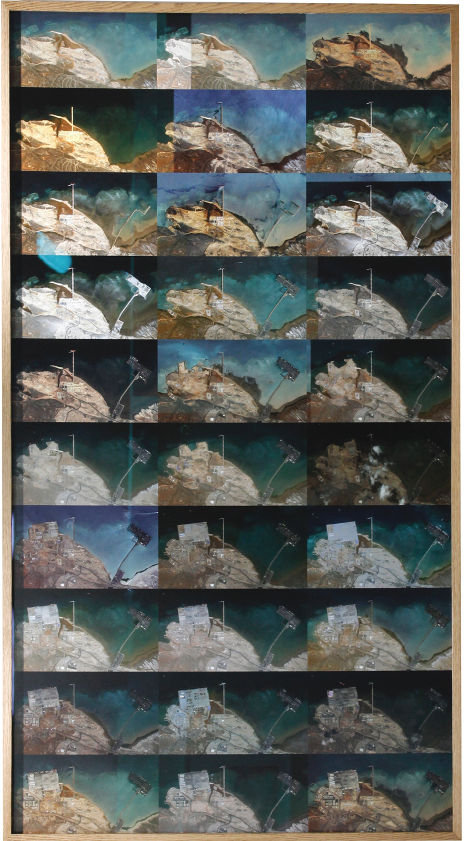
The second step envisaged combining the acquired economic data with photography and fundamental theories of countermapping. Once we extracted and paired geodata with the financial data, it was possible to localize specific Chinese infrastructure investments (such as dams, roads, railways, ports) worldwide via publicly available satellite imagery. We subsequently created a semi-automated script that automatically captured hundreds of these images from each location. Once stitched together, the picture was then printed in large format (approximately 150x300cm) depicting distinctive details of the site and the activities in the area. I titled this series "Almost Automated Landscape of Economic Interest". This global perspective allowed to "observe" and "photograph" the activities financed by China and, in some cases, to capture the environmental impact of such activities
Local Perspective:
Finally, from the first two steps and a more traditional journalistic research, it was possible to plan a series of photo survey "expeditions" to specific locations. More should be told about the practice of "photo survey expedition" which was mainly developed in the nineteenth century as a practice that, by numerous scholars in photographic theory, is associated today with the campaign of colonialism and exploitation of natural and human resources. I do not intend to dig into this theme on this occasion. Still, I like to underline that the images, mainly of landscapes, I realized during my fieldwork, perform on the one hand the same aesthetic function as the ones adopted during the nineteenth-century expeditions. Nevertheless, and most importantly, they differ from them as they do not look at resources that offer surveys for exploitation. On the contrary, they look at the damages already caused to the environment and the society by an exploitative power. In this case, the Chinese's economic power. In this sense, my images appropriate the same aesthetic and narrative characteristics of the old photographic practices to counter-map and challenge both the Chinese economic power's exploitative practices and the photographic strategy of the nineteenth-century "photo survey expedition".
For simplicity and to better illustrate the project's practice and results, I will describe a few images for each Technical Visualisation adopted. I will also focus on only two geographical locations to better highlight the advantages of using the three different perspectives in the aesthetic and analytical observation of the Chinese expansion and footprint.
The first image "Almost Automated Landscape#1" is the result of applying the Global Perspective view to capture the southeast part of New Lanzhou, near the airport. The image is composed of 120 satellite images stitched together. It is clear from the photo the new urbanization of the area, the field which was converted into a construction site and dwelling buildings.

Almost Automated Landscape #8, 2020. ©Davide Monteleone.
In the following picture, a view from the same area realized from the field with a drone. The construction of this city clearly implied a total modification of the landscape and the social structure in place with apparent damage to the environment and the society. One of the quotes I noted from a local worker was that "the authority literally moved mountains" to make space for the new city. The third image is captured with a large-format camera from the hill overlooking the new fast railroad. It depicts the quintessential representation of the "Belt and Road" initiative and the Chinese ambition: in a desolated city in the middle of nowhere, the newest and bullet train representing the symbol to connect the world and behind it the symbols (replica) of Europe, Africa, and Asia: the Parthenon, the Sphinx, and the Forbidden City.

New Lanzhou, China, 2018. ©Davide Monteleone.

New Lanzhou, China, 2018. ©Davide Monteleone.
To put things into context, I also wanted to see how things change from a timescale perspective, so I used satellite images as a sort of time capsule to create a series of video showing the progress of development of various Chinese project over the years. In the same way, I used the satellite multiple frames to produce a large print like the one below depicting the Doraleh Port in Djibouti over the course of 8 years.

Screenshot from “Timelapse Sinomocene”, 2020. ©Davide Monteleone.
Djibouti Port, print ed.#1, 2020. ©Davide Monteleone.
Therefore, the project may be presented in the form of installation, focusing on a specific geographic location. It may incorporate multiple geographical areas represented by the three technical visual perspectives or presented as a series of photographic prints accompanied by interactive or semi-interactive data visualization. Suppose the project's first purpose may seem to depict one of the most ambitious and debated economic enterprises of our time. In that case, the construction of it also attempts to challenge traditional photography's ability as the right means to represent impalpable issues. Because of the underlying geopolitical nature with any country's ambitions of international influence, this work is interconnected with some of the most urgent global issues of our time relating to soft power and cultural integration, environmental conservation and inclusive economic development, and international power and fragmented sovereignty. All these topics present by nature an amorphous nature to grasp and comprehend. As such also previous forms of colonialism. Nevertheless, it must be noted that there is a significant difference. While prior colonization required a physical presence and, in most of the cases, also physical violence, forceful occupation, an army, and in numerous case a war; the Chinese experiment relies almost exclusively on money and financial advantage. This new form of colonization, which has also been described as an "economic trap", has unfortunately for me, little appealing in term of visual representation and, for this reason, required a more elaborate narrative. It may seem not to - but it does - produce the drama of war, the tragedy of poverty. It doesn't immediately seem to expose issues related to human rights abuse. Clearly, it does. But it does it in such a subtle way that his representation does not readily offer the aesthetic possibilities and tropes typically exploited in photojournalism. "Sinomocene" is therefore also an attempt to investigate the possible visual representation of apparently invisible or "un-photographable" issues of our time.
Credits:
Data Analysis and Vizualizaation:
Davide Monteleone, Viraj Parikh, Interactive Things
Data Sources:
AidData: Geocoded Global Chinese Official Finance
American Enterprise Institute: China Global Investment Tracker
Australian Strategic Policy Institute: Mapping China’s Tech Giants
Chinese Ministry of Foreign Affairs: Overseas Diplomatic Missions
Hanban Institute: Confucius Institute Annual Development Report
International Monetary Fund: Direction of Trade Statistics
Kiel Institute for the World Economy: Working Paper 2132, China’s Overseas Lending
Transparency International: Corruptions Perceptions Index
United Nations World Tourism Organization: Bilateral Tourism Matrix